Tag Archives: China

Kulangsu 鼓浪屿 – 2017

DSC05176a
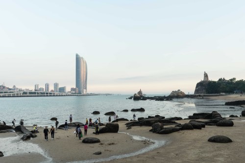
A lot has happened since I last set foot on the streets of Gulangyu islet. Most significantly, in summer 2016, the islet and its unique architecture was added to the UNESCO World Heritage List. To those of us from new world countries, it’s difficult to get our heads around exactly what UNESCO listing means, and UNESCO themselves don’t make it much easier with their excessively-academic descriptions: “[The islet’s style] shows a transformation of traditional building typology towards new forms, which were later referenced throughout South-East Asia and became popular in the wider region.” But in the case of Gulangyu, a tiny islet off just the coast of Xiamen (China’s ‘capital of cool’ according to CNN Travel this year), UNESCO listing means fortified protection from the rampant demolition and high-rise, high-tech development that’s happening five minutes ferry ride away. It means the late 19th and early 20th century buildings, erected by Xiamen locals, wealthy overseas Chinese, and the occasional European merchant, carpeting the islet’s suburban interior and woven together by its tiny twisting lanes, will be restored instead of replaced. It means many of those properties now have erected wonderfully descriptive plaques, in near-perfect English, detailing their individual histories and their architectural significance. It means strict limits on the number of tourists that can visit the islet – 35,000 per day where once upon a time the islet hosted three times as many. And it means everyone outside China has started referring to the islet not by its Mandarin name “Gulangyu” but by its Hokkien dialect name Kulangsu.

DSC05214b

The backstreets of Kulangsu’s Longtou district

In fact much of the language harks back to the beginning of last century. Kulangsu’s architectural style, which UNESCO tells us originated here and spread to other parts of China, Taiwan and South-East Asia, takes the old Hokkien-European name Amoy Deco. The English language summaries of the islet refer to the adjacent river mouth by its old colonial spelling Chiu-lung River. And the rectangular carpet of grass fringed by palm trees and grey stone buildings at the corner of Huangyan and Zhonghua roads, which 140 years ago began hosting cricket and tennis matches, is generously named the Foreigners Football Field (in Chinese, though, its name is still the regulation proletarian 人民体育场 – “People’s Stadium”). The old colonial terms can be found on the plaques outside the UNESCO inscribed properties, some 50-60 of which are scattered across the six nominal tourist districts on the islet.

DSC05285b

The lakes of Shuzhuang Garden, with Sunlight Rock towering to the north

The properties are many and varied; as diverse as a Taoist temple, a protestant church, a residential family villa, and the offices of a Shanghai-based Dutch oil company. The text on the plaques is accompanied by historical black and white photographs, architectural elevation diagrams, and cues for the Kulangsu official audio guide. At important crossroads, the visitor can find maps of the district and a summary of its importance in the wider context of Kulangsu’s history, which included traditional fishing settlements long before Xiamen’s 18th-century rise to major trading port status. All of these changes have opened Kulangsu up to the average overseas tourist and transformed the islet. Where once we found a mere quirky curiosity, Kulangsu is now a comprehensible destination that can be placed in the wider context of the multicultural East and South-East Asian trading communities, and of European engagement with Asia. This is important, because outside China little is known of this world where the west and the far east have been interacting for centuries, and increasingly inside China this interaction is portrayed as a shallow and wholly negative experience.


DSC05245b
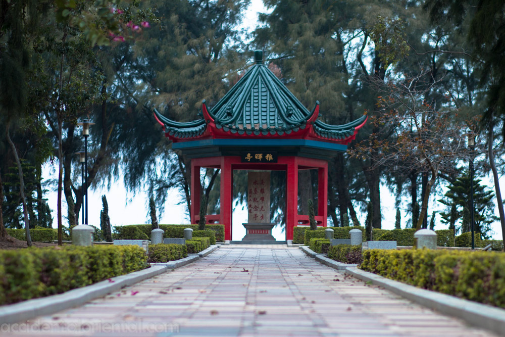
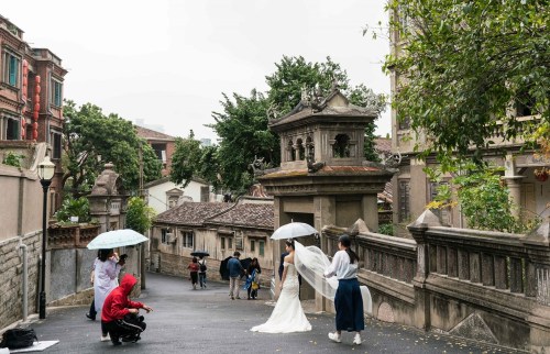
What hasn’t changed on Kulangsu is just as pleasing as what has. There’s the geography. Sunlight Rock, the 92 metre-high stone summit from which Zheng Chenggong surveyed his dominion in the early days of his 17th century resistance, still dominates the more populated southern half of the islet. Beneath the rock, the delightful arrangement of hillside paths, bridges and seaborne stone steps that make up Shuzhuang Garden wend their way through rock gardens, up and down coastal cliffs, across inlets and out into the waves opposite the mainland shore at Zhangzhou Port. The rolling and twisting lanes in the northern portion of the islet, around the Neicuo’ao district, remain leafy, local and relatively free of the tourist trade that dominates the Longtou district in the centre of town. It’s around Neicuo’ao too that the visitor can still get a glimpse of the blackened and aged 20th century buildings unrestored and overgrown, that once proliferated prior to the UNESCO listing. The crowds haven’t changed, either. Despite the reduction in tourist numbers, the Longtou district retains its energy, buzzing into the night thanks to 24 hour ferry services to and from Xiamen, and a vast improvement in the accommodation options on Kulangsu. The bridal couples are still there, around almost every corner, sprawled across church gardens, trailing their dresses, dragging wardrobe suitcases and followed by teams of photographers and make up artists. And inexplicably, the popularity of eccentric desserts continues unabated – where once everyone bought pineapple cake from Miss Zhao, today the tourists lug brightly-coloured bags of tropical fruit tarts made by Durian & Mango Deeds. Thanks to UNESCO, with the unique character of Kulangsu’s 20th century architecture articulated for us, it feels like we’re now freer to be bamboozled by the equally peculiar nature of Kulangsu’s modern Chinese tourism.

DSC05148b

Life in the Longtou district of Kulangsu


Leave a comment

Filed under Uncategorized

The Kizil Caves

One morning in early July, our bellies full of fresh lamb samosas, my taxi driver Mehmet and I found ourselves in the vast Xinjiang countryside. We were more than an hour from home, bound for the Kizil Caves, a collection of Buddhist grottoes dating back 2000 years, the likes of which are surprisingly common in Xinjiang. These majestic tourist attractions are dotted around the Silk Road oases of the province. But they’re rarely close to the cities, or each other, so long highway journeys are in order for the visitor, through often barren and rocky expanses. By some rotten luck I had yet to step inside a cave this trip, so I was desperate to see the Kizil Caves, outside the oil and gas city of Kuche, a sparkling and strangely empty new town wedged beside a down-at-heel historical old village. But now, I was standing beside a highway, next to a soldier armed with a QBZ-95 machine gun. And Mehmet was nowhere to be found.
IMG_4614

Rewind to the previous day. Baby-faced Mehmet (he looked like a younger, less-annoying Gilbert Gottfried) wasn’t “my” taxi driver. He was one of Kuche’s many local cabbies, who just happened to be passing by when I emerged from the hotel looking for a lift to the city’s Grand Mosque. I flagged him down and he promptly dropped me at the mosque, down a dusty street in the old town. Instead of driving off, Mehmet offered to wait outside while I visited. He must have been well aware that the building lacked any of the grand-ness in its title, and that I’d need a lift somewhere else fairly soon. I paid my fee at the booth before entering and lingering, alone but for a pair of curious toddlers, about the mosque’s courtyard in contemplation. I wondered how I would fob Mehmet off and instead explore the streets of Kuche’s old town on foot, searching for my first meal of the last day of Ramadan. That idea withered and died, however, when I exited the grounds and saw five armed policemen, all ethnic Uyghurs, had assembled outside the mosque, playing with the local children and casting occasional glances my way as I passed through the heavy gate. As I settled back into Mehmet’s taxi, the policemen stood up as one, and wandered off, shooting warm welcoming smiles at me through the window. Paranoid that I might be the only foreigner in the old town and receiving unnecessarily close attention, I took the opportunity to ask Mehmet to take me straight to breakfast – to his choice of restaurant for polo, a typically central Asian dish of rice, vegetables and lamb. His face lit up at the suggestion, and off we went, to a new-build place comfortably back in the soulless broad boulevards of Kuche’s new town. The restaurant was full, so I was shown to the last remaining table, crammed near the kitchen. There I was joined by two more Uyghur policemen, who smiled at me before tucking into their bowls of laghman, Xinjiang’s famous, and ubiquitous, noodle soup. As I paid for my meal, Mehmet was waiting, and together we agreed that my afternoon visit would be the 1600-year-old ruins of a city 23km out of town called Subash. By the time we returned to Kuche that evening, together we’d planned the Kizil Caves trip and agreed a time for Mehmet to be pick me up next morning.

The next morning was Eid – the end of Ramadan, roughly the Muslim equivalent of Christmas. But Mehmet’s dedication to his faith (and indeed his family) can’t have been above his business, because he’d already given his whole day over to driving me around the countryside. After buying roadside samosas to eat in the car, we stopped to get gas. In Xinjiang, all passengers must wait at the entry to the gas station while the driver refuels, so I stood there by the highway in my dusty hiking shoes and faded shorts, next to families dressed their best for the day’s festivities. Women wore bright reds, yellows and orange colours, their shiny high heels digging into the sandy road shoulder. Men sported crisp dark suits and combed mustaches, and children in pressed trousers and flowery dresses cavorted around and between their parents’ legs.

IMG_4929

The Kizil Caves – no photos are allowed once inside

After about an hour of highway driving, we came upon what appeared to be some kind of toll booth. About twenty cars were lined in single file and Mehmet coasted our taxi to a stop. Several Uyghur policemen with shotguns and heavy flashlights approached. I was asked to get out and walk the next fifty meters, through a security checkpoint. One policeman smiled and asked to see my passport, which fell open on the arabesque swirls of my Iranian visa.
More background: The Uyghur language, which all young Uyghurs can speak and read, is written in the Arabic script. (This wasn’t always the case – the Chinese government has switched from Cyrillic to Latin and again to Arabic in the 67 years since 1949.) So Uyghur policemen can’t read our passport pages, and often they struggle with the Chinese on our tourist documents and their very own passports.
But the young man had little trouble extracting my information from the 2013 visa issued by the Islamic Republic of Iran. “Allah!” he read aloud, looking at me with incredulity. The joy written across his face told me I was the most interesting thing to happen to him this shift, on this most festive of days. He led me into the security check and I was whisked through the metal detector and ahead of the patient queuing Chinese foot traffic like some kind of VIP. Several other Uyghur staff gathered round the ID check window where my passport was handed across a desk. One looked up at me and said “Assalamualeikum” to which I instinctively smiled and replied “Waaleikumassalam” They all thought I was a fellow muslim! “What do you do for a job?” they asked in Chinese. Was I married? Where was I from? “Aodaliya! (Australia!)” I spat out hastily. “Oooh Antalya!” they cried in chorus, realising I must be from Turkey. “No, Aodaliya” I corrected them. “Yidali ma? (Italy?)” they asked. My Chinese wasn’t having a good day. Before I could ask for my passport back, to show them the kangaroo on the coat of arms, the whole joyous spectacle had attracted the attention of their superior, a tall, broad, square-jawed Han Chinese who appeared over my shoulder. The playful air was sucked out of the road-side security hut immediately. He rifled through the pages of my passport to find my valid Chinese visa. The question of where I was from returned, in the form of a serious interrogation. What was my occupation? Why was I in Xinjiang? Where was I staying? Mehmet reappeared, helping me answer the superior’s questions as best he could. And when the superior was satisfied, he handed my passport back, and said goodbye. The young policemen continued to chat to Mehmet and they asked me whether I liked Xinjiang, where I was going and where I’d come from, and then bid us a warm farewell as we departed. When we reached the car, Mehmet told me to stay out, and that he’d be back in five minutes. And then he drove off. I stood in the July sun, beside the stern-looking soldier in an armoured vest, carrying the standard-issue QBZ-95 Chinese military machine gun.

Mehmet took longer than five minutes. All up it must have been twenty or thirty, but it felt like an eternity. I’d been unnerved by the exchange at the checkpoint, worried that the several Chinese visas in my passport, combined with the Iran visas, might have been too peculiar for the tall, humourless Han superior. I felt guilty that Mehmet might have been subjected to more searches than he otherwise might have, all because of me. Underneath all of the informal warmth of Xinjiang, there’s still the very serious matter of security. And anything out of the ordinary demands closer scrutiny. Probably hundreds of people like me pass through that checkpoint every year with funny names, strange passports and exotic visas. But they’ve got to check. There’s a process to follow. No need to worry.

One of the frescoes from the Kizil Caves

An example of the Kizil Cave frescoes (source: Wikimedia Commons)

The Kizil Caves were worth all the time and effort. Their collective story is remarkable: 236 cubby holes hewn by holy men into a barren hillside overlooking the Weigan River plain; peaceful places of worship overcome by the desert and 2000 years of regional power shifts, in parts plundered and vandalised, and now protected by Beijing in one of Xinjiang’s few truly positive national initiatives. Their “discovery” by the European powers was a coveted prize in the bitter contest between Great Game rivals Albert von le Coq and Aurel Stein at the turn of the 20th century. The soft blues and pinks in the wall paintings came from India and Afghanistan and the frescoes’ artistic style, like the very people of Xinjiang themselves, descends not from China but from the Indian, Turkic and Greco-Persian cultures of central and south Asia. At dusk, before I returned to the hotel, we tucked into laghman and Turkish tea in a Kuche chaykhaneh – the Persian word for “teahouse” that is understood all the way to Europe. There we were accompanied only by curious waiters and cheery families – paranoia subsided and not a policeman in sight.


Postscipt:

I feel I must note that in the last year or so there have been horrifying revelations of mass incarcerations in Xinjiang broadcast on major news outlets like the BBC and the New York Times. One should always be wary of stories that confuse the PRC’s brutal campaign against Uighur separatism, one with roots much deeper than those of the PRC itself, for a campaign against Muslims in general. And journalism in the West has a track record of sometimes being too heavily influenced by pro-independence elements in the diaspora – in this case the Uighur and Turkic diaspora. But after all I’ve read, I have no doubt that the highway checkpoint in my story is an element in the security infrastructure that is being used to incarcerate hundreds of thousands of innocent people for the diabolical purpose of “re-education.” At that checkpoint there was a process to follow, and for me there was indeed no need to worry. But that wasn’t the case for Mehmet or his fellow Uighurs in that security hut. They might have worried for family or friends that had already disappeared, or for the very real prospect of themselves being taken away at a moment’s notice to be imprisoned for an indefinite time, under spurious pretences.

Leave a comment

Filed under Uncategorized

Xinjiang Gallery

Leave a comment

Filed under Uncategorized

6 Things That Are Obvious In China (But Not in Australia)

Kashgar in far west Xinjiang, China, has had a fresh injection of investment and its old town spruced up


1. China’s bigger and more diverse than we can imagine. And it works surprisingly well.

The 400km Karakoram Highway, ancient silk route, resembles one vast construction site, with investment from all over China


2. Facebook is small fry compared to China’s WeChat, and is forced to follow them. Chinese tech companies are in the ascendancy, and the likes of Apple and Google know it.

WeChat is how most people in China chat, share and, increasingly, WeChat Money is how they buy and sell things


3. The runaway economy in China’s east may have slowed to a steady jog, but the boom in the west is just beginning: the riches on the coast are being invested inland. And it will carry countries like Pakistan and Afghanistan with it.

Evening crowds in front of Kashgar’s Id Kah Mosque

4. Whatever concerns we might have with corrupt governments in China, Central Asia and the Middle East, they’ve probably got a bright future ahead, and we’ll have to adjust.

A tourist in the shiny new part of Turpan, an ancient Silk Road city

5. The benefits that we once enjoyed just for speaking English, or for having a western education, are becoming less and less. Our children can’t afford to ignore Asia’s languages and cultures, to be as complacent as we were.

After dark snacks and juices in Kashgar’s freshly-renovated old town

6. Electing leaders who are clueless about and dismissive of the Middle, Near and Far East will not make anyone great again. It will only accelerate our decline.

1 Comment

Filed under Uncategorized

Throwing Rocks at 13000ft

At around 4200m above sea level, perched on a rocky slope and huddled in layers in the shade, I hurled my last stone into the rushing torrent below. It had been a motif on this trek, throwing stones, shifting slopes, the clinking sound of small rockfalls and the unpredictable splashes when they hit water. Instead of chucking the things I decided to copy the local shepherds, engage in a more constructive exercise and stack a small cairn while we rested on our descent of Muztagh Ata – the ‘Father of Ice Mountain’ in China’s far western Xinjiang province.

We got here via the Karakoram Highway, a road route from the city of Kashgar and on to Pakistan, over the imposing Khunjerab Pass, that encompasses much of the ancient Silk Road route. Until the latest collosal construction project is complete (late 2016), the route is a bumpy off-road experience, taking roughly 7 hours to complete the barely 200km between Kashgar and our first stop, by the western shore of Karakul Lake. Along the way, army green trucks flying the PRC flag stalk the highway in convoys, transporting coal and iron ore. These commodities are the sole property of the government 4000km away in Beijing. The Uyghur, Kyrgyz and Tajik urban and nomadic communities of the area, in their ‘autonomous counties’ have no stake in the riches beneath their feet. Construction on the highway is carried out by companies from across the PRC, from faraway places like Shandong and Guangxi. A new dam and hydroelectric power station has been built beneath the imposing Kongur mountain, creating a new lake and sinking the winter pastures of the local Kyrgyz villagers, and a part of the old Silk Road. Just like the housing developments in Xinjiang’s cities, financed by municipal goverments like Shanghai and Shenzhen, these projects that flow on from the discovery of western mineral wealth are eastern ventures, and the locals of the west will have to take advantage where they can, or be damned.

They are doing just that, as evidenced by our very presence, renting Kyrgyz villagers’ homes as part of an organised tour. The villagers are also by the roadside hawking jewellery and traditional headwear when the Han Chinese spill from their enormous tour buses for photos by the lakes. These are resilient communities that have seen their fair share of cataclysmic changes and tyrannical rule, and the belated arrival of the full force of the PRC juggernaut is just the latest.

For our first day’s trek we set off clockwise around Karakul Lake, as if traversing an ancient Buddhist circuit. The skies are clear and the views of white capped mountains in almost every direction are breathtaking. We pass through Kyrgyz winter villages, deserted except for the odd curious family. The children usually stare wide-eyed at us strangers until we wave to them, then they crack a smile and hide behind their mother or each other. The clear skies prevail, and the daunting peak of 7500m Muztagh Ata, our purpose, watches over us to the east throughout the day. We pass the odd local on a motorbike, plying the dirt trails between villages. Our guide and donkey driver greet them warmly and uniformly: a smile, the right hand placed on the heart, ‘assalamaleikum (waleikumassalam)’ a firm shake of the right hand, and it returns to to the chest, as inquisitive conversation begins. It’s repeated all over Xinjiang, but here in the mountains there is that warm, rural, genuine concern that inhabits the countryside the world over.

Walking the eastern edge of Karakul Lake, the ink black water is so calm, the stratified tan foothills of the Pamir reflect so clearly that peering over the edge feels like staring into an abyss, the sky deep beneath our feet. We leave the lake behind us, swing around a small hill and across a valley of grassland to a house in the village of Idara – a collection of stone houses with a modest mazar (cemetery) on the western side. The almost 18km walk is exhausting. We’ve barely gained 50m in altitude, but there’s extra effort in even the simplest of tasks at 3700m. Idara is a winter village, but in mid July the family are there to host us for the night, to return to their cattle higher up the slopes as soon as we are gone. To our east, the day’s last rays of sunlight glint off the western glaciers of Muztagh Ata, and the clouds clear for a cold, starlit night.

The next day it’s an 8km walk, 400m up to the busy summer village of Qaltamuk, full of lounging juvenile yaks and energetic children on their summer holidays. We cross a vast pebbled riverbed. The streams running through it are high enough that at one point we are forced into our first effort at rock-throwing: establishing a series of stepping stones to traverse the bubbling waters. Across the grasslands beside the riverbed rust-coloured marmots chirp their warning signs to each other, keeping their distance and stood so still they resemble the rocks that dot the hills. We have a brief lunch in Qaltamuk in the early afternoon before attempting to reach the glacier on Muztagh Ata. The ascent is slow and conversation scarce. Marmots chirp somewhere nearby. We cross a herd of bolshy yaks grazing the upper slopes. Between sips of water and gulps of thin air, we snack on Albeni bars – a kind of Turkish Twix. When the grass slopes end we scuttle over the rocks that the retreating glacier has long since left lie, towards its crumbling ice fringes. We reach 4500m. That’s as high as we’ll get. Rain and hail begin to fall, and the mountain is obscured by clouds except for the white wall lower reaches of the glacier. We hang out at the glacier, grinning for photos beside giant blocks of ice and topping up our bottles with crisp, fresh glacier melt. The weather eases and we begin our difficult descent along the moraine, following the path of the ice. Climbing was tiring, but simple and repetitive. Descending loose rocks requires concentration. We rest often, and throw, or stack, rocks in contemplation. The sun comes out. The cavernous sound of rushing water echoes beneath the glacier, and silvery trickles drip from the melting ice to our right. These drips become the waters that divert through the summer village where we will sleep and fill the pebbled valleys far below. They paint green the grasslands where marmots burrow and horses graze and each ever so slightly lifts the level of Karakul Lake. Unlike where I come from, water is plentiful here and electricity is not.

We return to Qaltamuk just before sunset and slump by the warm stone house stove, spent. Our Uyghur guide and Kyrgyz donkey driver roll out their rugs and pray with the hosts, as they have done each evening, night and morning throughout the trek. They whisper Bismillah before our meal of white rice and fried vegetables, and offer thanks with Alhamdulillah after, placing their palms up and then covering their face before clearing the plates. These Sufi traditions sit comfortably alongside the more ancient superstitions that attribute a divine nature to the mountain, and respect for the countryside and the food on their table – echoes of the region’s Buddhist, and pre-Buddhist, past.

Our appetites shot by altitude, we’re grateful too for the mouthfuls that we managed. And for our descent next morning, back across the river via another rocky crossing. Then further down the highway and into the next valley, where the weather is warmer and the air is thicker. As the stone house lights go out and rain falls on the roof, I wonder how long my little stack of 6 rocks will last, so close to the water’s edge, and with winter not far away. Will the shepherds acknowledge it? I’ll never know.

Leave a comment

Filed under Uncategorized

Flight CZ6888 CAN-URC

Most flights pass by with little incident, each one predictable, indistinguishable from the next. My flight from Guangzhou to Ürümqi in Xinjiang was not one of those.

The first thing that struck me was protruding from the seat pocket in front of me – on the pamphlet of safety instructions, the usual Chinese and English characters were joined by the Arabic script. Xinjiang is the only part of China where Arabic is used, for the Uyghur language, spoken by more than 40% of the province.

IMAG0026-01a

China Southern’s Safety Instructions – in Uyghur, Chinese & English

This was the first time I thought I’d noticed an air marshall on a plane. Tall, with close-cropped hair and a deep crease bisecting the back of his head, the man one row in front would periodically strut the cabin and un-selfconsciously eye the passengers with a mixture of boredom and suspicion. I knew what he was for sure when he abruptly ordered the cabin crew to tell me to turn off my “shou ji”, my mobile phone. They and I fell into line without reply.

About 2 hours into the 5 hour flight, looking out the window offered a birds-eye view of a moonscape. Parallel to the plane ran a spine of desolate brown crags, their tops scattered in the summer with snowdrift. Perpendicular to these peaks, long winding ridges of rock fell away, twisting into the distance like the backs of giant alligators. They dwindled to shallow bumps and eventually into dark ripples of sand dunes. As far as the eye could see, there was no sign of life; no road, no river, no farm, no village. Desolate China; her own big, broad Badlands.

IMG_4502

Naan bread for sale in the streets of Turpan, near Urumqi

Before our descent, an African man with a francophone accent, dressed in jeans and t shirt and wearing a silver crucifix, sat next to me briefly. He told me was on his way back to Kyrgyzstan, having missed his transit to the Philippines in Guangzhou. It seemed an unlikely story, so I politely declined his request for help, assuming he’d manage okay.

The long approach to Urumqi Airport passed over a flat expanse of bland urbanisation, dominated by an ugly, orderly collection of asbestos blue warehouse roofs. At some distance, through the industrial haze shone the snowcapped Tianshan, the “Heavenly Mountains” of Central Asia, which Xinjiang shares with Kazakhstan and Kyrgyzstan.

20160630232251_IMG_4473-01

Late night kebabs in Urumqi

As we disembarked, we passed the air marshall in the jetway where he was placing the African man in handcuffs. Behind them in the west set a toxic orange sun. Less than an hour later I would be ordering lamb kebab and ayran after iftar in a bustling Uyghur cafe across from my hotel – a late night snack and a welcome to Xinjiang fittingly following such a peculiar flight.

Leave a comment

Filed under Uncategorized

MorningCalm Article on Xiamen

Korean Air Title I wrote a special destination article and three feature sections for the August edition of Korean Air’s in-flight magazine, MorningCalm, about Xiamen, Quanzhou & the Hakka villages of south Fujian (requires Adobe Flash.) The accompanying photographs are by Boaz Rottem of Boazimages.

MorningCalm is perhaps the most beautiful in-flight mag I’ve come across; the preceding article on Bukhara and its stunning photographs by Marc Dozier are well worth a look, too. Korean Air Cover

Leave a comment

Filed under Uncategorized

Pingyao

The Pingyao city wall at dusk

In the last couple of decades, the popular image of China, at least outside China itself, has become a very modern one. Much in the same way that Japan’s rapid modernisation subsumed an ancient “shoguns and ninjas” image and replaced it with a hi-tech, futuristic one of robots and intelligent lavatories, China’s recent boom has brought some rather more unsightly stereotypes to the fore – smog, factories and endless apartment block developments among them. When we visit the big-ticket tourist cities, Beijing, Shanghai and Xi’an, we often see one or all of these, but we do it for some small and carefully-preserved piece of China’s history – Old Shanghai, the Imperial Palace Museum, or the Terracotta Army. After those fascinating exhibits, the cities around them feel like a strange mix of luxury stores, grey cookie-cutter apartment blocks and ultra-modern, ambitious and sometimes ridiculous new construction. In the People’s Republic’s rush to create a communist utopia, and the resulting u-turn and plunge into a market economy, Chinese life has changed, seemingly completely. So, one begins to wonder, where is a living version of old China? One that pre-dates the Cultural Revolution and isn’t cluttered with tourist shops and ticket booths? One answer to that question is a little town in remote Shanxi province, called Pingyao.

One of Pingyao's shopping streets

One of Pingyao’s shopping streets

Pingyao has a long history. Situated roughly halfway between Beijing and Xi’an, it has been in the company of the centres of Chinese civilisation for over 2000 years, and held a position at the eastern end of the trans-continental Silk Route. But it was more recently, during the last throes of the Qing dynasty, that the city amassed much of its riches. It was in Pingyao in 1823, as wealth in the form of silver moved across the vast empire to finance development and occupations, that China’s first bank emerged. Business boomed and Pingyao spawned several banks, with branches across the empire and as far away as India. It all went well until the fall of the Qing in 1911, by which time the wealthy banking families of the city had built impressive homes and amassed enviable art collections. The 20th century was unkind to Pingyao as the business centres shifted to the coast, industries were nationalised, and Shanxi’s national role was reduced to the extraction of coking coal. The upshot of Pingyao’s descent to the fringes, however, seems to have been its protection from modern China’s relentless development and the preservation of the city’s precious heritage.

Pingyao's West Street (Xī Dà Jiē) at night

Pingyao’s West Street (Xī Dà Jiē) at night

Pingyao has been surrounded by a city wall for over 2000 years, but the wall in its current form has been in place since the Ming dynasty in the 14th century. Its 6km length encloses and overlooks a criss-cross of tiny lanes, marshalled by 2 perpendicular main arteries. The southern half of the north-south artery, South Street (Nán Dà Jiē), is the most heavily-touristed, straddled by an ornate gate and lined with shops selling tourist nicknacks, eclectic collections of antiques, and restaurants and cafes. South Street also finds itself among the bulk of the tourist attractions and guest houses in the city, heavily trod by large Chinese tour groups and a smaller crowd of foreigners. There are two temples and four bank museums in the southern half of the city, as well as two double-entendred “escort agency” museums. Some of the attractions date from over a millennium ago, and each reveals a precious piece of China’s history, chief among them the pioneering Rishengchang Draft Bank Museum, with a room full of treasures dating back to the Song Dynasty. The Rishengchang Museum is part of a city-wide entry ticket of 120RMB that includes a number of attractions and is valid for three days. But the beauty of Pingyao is not only in the draft banks and temples, but also in walking its sometimes-restored, sometimes-rubble-strewn dead straight lanes.

The extent of the branch network for the Rishengchang Draft Bank in Pingyao

The extent of the branch network for the Rishengchang Draft Bank in Pingyao

Turning off the main streets, the touristic nature of the lanes quickly dwindles, but the ancient village architecture never does. Dark brick façades rise either side of you and the sky forms a thin strip over your head, the horizon in front obstructed by an ornate gate in the near distance, or one of the watchtowers on the city wall. The occasional electric bike creeps up behind and rushes silently past, while elderly locals rest outside their houses, watching Pingyao life go by. At night the lanes are strung up with red lanterns to light the way – until they’re not, and the path is pitch black, haunting bike lights in the distance mixing with the faint smell of heating coal and the cool night air to give an otherworldly feeling to your evening stroll. The outskirts are dotted with construction as new buildings are being built with similar materials in a similar manner to the old, and it’s sometimes difficult to tell the difference between ancient and new. But there are a number of hotels and guest houses, such as the Yide Hotel in the city’s western half, set in courtyard complexes from the city’s golden era, whose success will likely be the guarantee of the preservation of much of the city’s wonderful heritage. And the city wall itself can be walked the entire perimeter, as part of the city-wide entry ticket, offering a rooftop perspective over an ancient Chinese city, still living, and finding its place in the new China without wholesale demolition and high-rise construction.

A small lane in Pingyao at night

A small lane in Pingyao at night

An example of new construction that remains true to the old in Pingyao

An example of new construction that remains true to the old in Pingyao

In the headlong rush to enrich a nation of 1.5bn and reach economic superpower status, heritage has been the least of China’s worries. But now that large numbers of Chinese are beginning to travel, and faraway parts of the country are accessible with airports and fast trains, it’s likely they will want to see what’s left of their precious ancient heritage preserved, that now they can afford not bulldoze the old and replace it with something new, but find the value in what’s there. We outside China can help too, by seeking out the genuine “old China”, by looking further afield than the big cities and digging deeper into a country that’s so much more than just smog, factories and high-rise glass-and-steel.

A courtyard at the Yide Hotel in the western half of Pingyao

A courtyard at the Yide Hotel in the western half of Pingyao

More about Pingyao:

The UNESCO Entry on Pingyao
An Article in the Financial Times
An Article in the Economist Magazine ($)

Leave a comment

Filed under Uncategorized

Hakka Villages of South Fujian

20140308-IMG_6966

Directly to the west of the city of Xiamen in southern Fujian, near the border with Guangdong province, nestled among rolling green hills of tea, rice and tobacco plantations are the villages of China’s Hakka ethnic minority. These migrants from the far north made their move as long ago as 300 AD, escaping poverty and persecution, and made a new home in the hilly Fujian countryside above the fertile river deltas. Initially unwelcome in this southern land, they housed themselves in imposing round multi-storey rammed-earth houses, impregnable and self-contained, a combination of family home and fortress. Little-known outside of the Chinese societies of east and south-east Asia, the Hakka have had a disproportionate impact on their part of the world since their arrival in the south, counting the revolutionary Sun Yat Sen, the former Chinese premier Deng Xiao Ping and Lee Kuan Yew, the father of modern Singapore among their number. But it is these curious giant mud houses, called tulou and ranging in age from 70 to 700 years old, that attract tourists to the villages around Yongding and Nanjing in Fujian in their busloads to learn about the culture of a people whose name “Hakka” literally means “guest”.

The heavily-touristed Huaiyuanlou building, with souvenir sellers lining the approach.

The four-storey heavily-touristed Huaiyuanlou building, near Nanjing, with souvenir sellers lining the approach.

The inside of the Huanjilou building, near the town of Yongding. The Outer ring of the building is for living, cooking, while the inner sections usually house areas for worship and bathing.

The inside of the 320-year-old Huanjilou building, near the town of Yongding. The Outer ring of the building is for living, cooking and storage, while the inner sections usually house areas for worship and bathing.

The postcard tulou cluster of Tianluokeng from above. It's the most picturesque collection of houses and makes it onto plenty of tourism material aimed at the Chinese market.

The postcard tulou cluster of Tianluokeng from above. It’s the most picturesque collection of houses and makes it onto plenty of tourism material aimed at the Chinese market.

Tianluokeng from below with our guide Helen (Fei Fei) and our driver Mr. Zhang (the Chinese Ben Elton).

Tianluokeng from below with our guide Fei Fei (Helen) and our driver Mr. Zhang (the Chinese Ben Elton). photo by Manal Shehabi

Many of the tulou have been turned over to government-approved tourist attractions so their ground floors, previously used for cooking, are now souvenir shops.

Many of the tulou have been turned over to government-approved tourist attractions so their ground floors, previously used for cooking the family meal, are now souvenir shops.

Some of the tulou are operating as family-run inns where guests can sleep and eat.

Some of the tulou are operating as family-run inns where guests can sleep and eat.

This is an inn in the villiage of Taxia near Nanjing city in Fujian.

This is Weiqunlou inn in the villiage of Taxia near Nanjing city in Fujian.

Taxia fits the bill for the typical Chinese village - a bubbling river flows under ornate bridges past red lanterned houses under terraced hills.

Taxia fits the bill for the typical Chinese village – a bubbling river flows under ornate bridges past red lanterned houses under terraced hills.

A Taoist temple in the Taxia village. Each pillar is a symbol of an ancestor who passed the Imperial Examination for the Chinese civil service - an achievement to which some men devoted their entire lives.

The approach to the Taoist temple in Taxia village. Each pillar is a symbol of an ancestor who passed the Imperial Examination for the Chinese civil service – an achievement to which some men devoted their entire lives.

A woman delivers offerings for her ancestors to the Taxia village Taoist temple.

A woman delivers offerings for her ancestors to the Taxia village Taoist temple.

The offerings take the form of (real) food and (fake) cash normally, lovingly donated by descendants still very much in touch with their roots.

The offerings take the form of (real) food and (fake) cash normally, lovingly donated by descendants still very much in touch with their roots.

The cobbles outside the privately-run Yanxianglou building. The family has eschewed the government tourism system and so enjoys less visitors but maintains a more peaceful setting. All around the walls are pictures of a successful uncle in the family who became a successful businessman in Indonesia and who returns each year to the family home.

The moss-and-firework-covered cobbles outside the privately-run century-old Yanxianglou building near Yongding. The family has eschewed the government tourism system and so enjoys less visitors but maintains a more peaceful setting. All around the walls are pictures of an uncle in the family who became a successful businessman in Indonesia and who returns each year to the family home.

Ornate eave decorations in the Yanxianglou building near Yongding.

Ornate eave decorations in the Yanxianglou building near Yongding.

A trader in the Heguilou building near Nanjing. The traders inside the more-touristy tulou might not always be descendants of the house clan, but they are all Hakka natives and their businesses very much family affairs.

A trader in the 200-year-old Heguilou building near Nanjing. The traders inside the more-touristy tulou might not always be descendants of the house clan, but they are all Hakka village natives and their businesses very much family affairs.

Leave a comment

Filed under Uncategorized

Jinmen

20140216-IMG_6362
The Fujianese island of Xiamen in China, including areas like Haicang on the mainland and the Gulang Yu islet, is a place full of day trips. There are enough places to see and things to do, and to see again and do again, that it could occupy a casual traveller for a very long time. But talk to enough people and you soon learn about another day trip – Jinmen. “What’s Jinmen?” goes the typical conversation.
“It’s a Taiwanese island you can get to by ferry”
“You can get the ferry to Taiwan???”
“Well, Taiwan is a long way away, but Jinmen is an island nearby that’s controlled by Taiwan”.
You see, back in the years following WWII there was a battle for China’s soul. Put simply, it was a civil war between the nationalist Kuo Min Tang and Mao Ze Dong’s communist Red Army. It was a titanic struggle and today, we still don’t have a result. The nationalists, who still claim to be China’s rightful government, were eventually pushed off the Chinese mainland and set up their capital in Taipei, 300km away on the island of Taiwan (as a side note, this explains why Taiwan competes in the Olympics under the name “Chinese Taipei”). With ambitions to re-take the mainland, they called their country the “Republic of China” (ROC), but most people simply call it “Taiwan”. Mao and the communists called their country the “People’s Republic of China” (PRC) and it is that which we now commonly call China.
But as well as the island province of Taiwan, the nationalists managed to keep hold of a few outcrops in the Taiwan Strait, Jinmen and its little brother Lesser Jinmen, officially belonging to Fujian province, being the closest of those to the mainland.

A temple gate in the Jinmen capital Jincheng.

A temple gate in the Jinmen capital Jincheng.

The ferry ride from Xiamen’s Wu Tong terminal to the Shuitou port on Jinmen is a sharp 30 minutes, but enjoys all the formalities of international travel – immigration, customs and duty free stores at either end and a fresh stamp in the passport upon emerging from the rather dilapidated facility in Shuitou. The line of taxis waiting outside belies the sleepy, countryside nature of the island. Either side of the quiet single lane main roads, rocky hills, partly forested sit behind semi-rural vistas of rice paddies and scattered houses.

Jinmen is the almost-X-shaped island just right of centre in the map above, and its brother Lesser Jinmen (or Lieyu) the smaller island to its west. These  outposts of Taiwan sit surrounded 180-degrees by the People's Republic of China and separated by a vast stretch of open sea from Taiwan itself. From this  angle it looks a miracle that they're still part of Taiwan at all.

Jinmen is the almost-X-shaped island just right of centre in the map above, and its brother Lesser Jinmen (or Lieyu) the smaller island to its west. These outposts of Taiwan sit surrounded 180-degrees by the People’s Republic of China and separated by a vast stretch of open sea from Taiwan itself. From this angle it looks a miracle that they’re still part of the ROC at all.

On the north eastern tip of the island lies Mount Lion, a fortress-come-museum tunnelled deep into a mountain with a 32km range Howitzer cannon pointing out to sea and the PRC. Thirty-two kilometres takes its shells well into enemy territory and so it’s a weapon of which they are rightly proud. The tunnels hewn into the rock are decked out with posters promoting Jinmen tourism and the exhibits along the way to the cannon offer the visitor imitation experiences of the theatre of war. It’s all very theatrical. I passed a mocked up war room where only a grandmother and her grandson sat colouring pictures. The lady, who was from Taichung on Taiwan island, greeted me and we chatted about her time in Australia briefly and then bid each other good day. Continuing up the passage, occasionally I passed a section of the tunnel that was walled off behind which I could hear mysterious voices chattering away.

Helmets on standby at the entry to the tunnels of Mount Lion Cannon Fort on Jinmen.

Helmets on standby at the entry to the tunnels of Mount Lion Cannon Fort on Jinmen.

The cannon is on the seaside of the mountain, dug in behind a lookout and accompanied by a noisy and patriotic video presentation reminding visitors of the times, as recent as the 1970s when the PRC engaged in regular shelling of the island, that Jinmen was the frontline in the battle for China’s identity. In fact it still very much is at the frontline, and it was there I concluded that the walled off sections of tunnel I noticed were for defence purposes and the voices coming from them must have been those of real soldiers. All over the sleepy island of Jinmen there are reminders of how close it has come to invasion and bombardment – the traffic roundabouts have concrete camouflaged pillboxes installed in preparation for invasion, the ports are scattered with sandbags and sea defences, and little Taiwanese toy soldiers are the most popular tourist souvenir.

Curious wedding photos adorn the walls of the tunnels at Mount Lion Cannon Fort.

Curious wedding photos promoting Jinmen tourism adorn the walls of the tunnels at Mount Lion Cannon Fort.

Descending the tunnels again, the cacophonous cannon presentation fading in my ears, I heard an arresting female voice barking orders coming up ahead and strained to tell if it wasn’t just another recording in one of the war history exhibits. When it became frighteningly loud, around the corner came about 12 uniformed troops marching towards me in formation. Hastily I put my camera away, abandoned the path down one of the long side tunnels and waited for them to pass. When I emerged from my self-imposed exile, the soldiers had stopped in formation a little way up the tunnel, facing back towards me standing alone in the tunnel. They began repeating another aggressive volley of chants as I retreated. Well aware that photographs of the military aren’t usually approved souvenirs, I dared not retrieve my camera and continued calmly towards the fortress entrance, allowing myself one furtive glance back at them as I descended. The tunnels were otherwise empty, as was the war room where I had chatted to the friendly locals, their paper and crayons hastily put away. I wondered if an invasion was under way.

The 32km-range Howitzer cannon at the Mount Lion fortress on Jinmen.

The 32km-range Howitzer cannon at the Mount Lion fortress on Jinmen.

The mystery was solved as I waited outside in the museum cafe for a cab to take me the 6km into the principal town of Jincheng. The friendly grandmother walked in saying “Hi! You missed the demonstration firing of the cannon!”. Distracted and unnerved by the ambiguous nature of the museum & fort, I’d missed the main event, the daily ceremonial firing of the Howitzer cannon.

A pagoda in Zhihui Park, a seaside garden near the western port of Shuitou on Jinmen.

A pagoda in Zhihui Park, a seaside garden near the western port of Shuitou on Jinmen.

The eastern side of Shuitou town, near the departure port for Xiamen and the PRC, has a collection of houses built in the Peranakan style, by a Jinmen businessman who migrated to Indonesia and made his fortune in the early 20th century. Peranakan, or Straits Chinese, culture developed in what is now Indonesia, Malaysia and Singapore as more and more Chinese migrated from Southern China and settled in South East Asia before, during and after the explosion of European trade in what was then known as the ‘East Indies’. There the Chinese, a great many from Fujian province, opened businesses in trading ports like Penang, Singapore and Jakarta, cities that were ‘melting pots’ centuries before the term came into common use. They formed large communities and kept their customs and dialects, but a culture all its own emerged under the influence of the Arab, Indian, European and native Malay trading society around them.

The eighteen-house Peranakan complex in Shuitou, with its distinctive defensive tower.

The eighteen-house Peranakan complex in Shuitou, with its distinctive defensive tower.

Many returned with their riches and built complexes for their families back home like the eighteen-house cluster in Shuitou. These particular Peranakan houses now form a low-key museum that celebrates the South East Asian, particularly Indonesian, Chinese culture. Peranakan dresses hang where the wardrobes would have been and the upstairs dining table is laid out with models of ‘baba nyonya’ dishes, the distinctive cuisine of the Straits Chinese. After the more confined and garishly-adorned local Fujian houses, walking into those airy hardwood spaces felt to me like slipping into a familiar pair of slippers. The furniture made of dark polished hardwood with intricate inlaid pearl designs, the high ceilings and dishes with the words “sambal” and “satay” recall a more laidback, tropical world than wintry, windswept Fujian in February.

Peranakan wall tiling and teak furniture in Shuitou, Jinmen.

Peranakan wall tiling and teak furniture in Shuitou, Jinmen.

The Peranakan houses, these curious South East Asian artefacts transplanted to Fujian by an unwitting pioneer of globalisation, are fascinating to the smattering of mainland Chinese tourists who manage to make it over to Jinmen. And it was these tourists who joined me in the departure hall at Shuitou port, and on the comfortable, half-full ferry back to the PRC and Xiamen. There’s an irony in the truth that Jinmen, this bitterly-contested outcrop on the eastern edge of Fujian, has preserved its precious heritage through the wars and bombardments, while relatively peaceful cities like Xiamen and those on the Taiwanese coast have had much of their heritage erased, not by conflict, but by development. So Jinmen* makes a refreshing way to spend a day away from the the crowds and traffic of Xiamen. It opens the eyes to a world that has stayed quietly hidden away, sedate and unchanged behind the rapid pace of the Chinese economic miracle that has in some way affected every one of us over the last couple of decades.

Examples of the ornate roofs of the traditional native Fujianese houses, well-preserved clusters of which exist all over the island of Jinmen.

Examples of the ornate roofs of the traditional native Fujianese houses, well-preserved clusters of which exist all over the island of Jinmen.

*Once on the island it’s almost exclusively called “Kinmen”, which is only an alternative way of sounding the first syllable, the Chinese word for “gold” (金 jin/kin)

1 Comment

Filed under Uncategorized